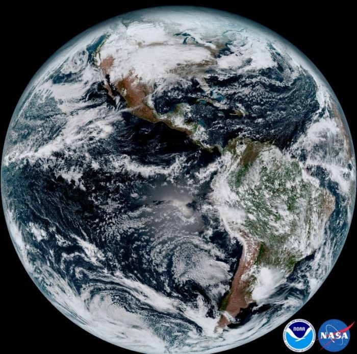
New Weather Satellite Captures Breathtaking Images of Earth in High-Definition
The National Oceanic and Atmospheric Administration's (NOAA) weather satellite today sent its first ultra-high-definition images of Earth which will lead to more accurate weather forecasts.

The image, captured by the satellite on January 15, 2017, shows Earth as a full disk from the equatorial view with North and South America and the surrounding oceans viewable in stunning clarity.
"The release of the first images today is the latest step in a new age of weather satellites," the agency said in a press release. "It will be like high-definition from the heavens."
The images were captured by NOAA's GOES-16 satellite which remains in a stationary position above Earth at an altitude of 22,300 miles. The game-changing weather satellite, which replaces the GOES-R, is the first spacecraft in a new series of NASA-built advanced geostationary weather satellites.
The GOES-16 satellite was launched from Cape Canaveral, Florida, on November 19, 2016, in a collaborative mission between NOAA and NASA. The '16' in its name refers to the 16 spectral channels it uses for imaging (its predecessor measured only 5 spectral channels) which gives it a resolution four times that of the existing GOES spacecraft.
The new satellite can provide a full image of the entire Earth every 15 minutes and one of the continental U.S. once every 5 minutes. With its incredible resolution, meteorologists and forecasters will be able to pinpoint the location of severe weather with greater accuracy. This will boost NOAA' prediction capabilities thereby making for more accurate and timely forecasts and warnings.
"This is such an exciting day for NOAA! One of our GOES-16 scientists compared this to seeing a newborn baby's first pictures — it's that exciting for us," said Stephen Volz Ph.D. director of NOAA's Satellite and Information Service. "These images come from the most sophisticated technology ever flown in space to predict severe weather on Earth. The fantastically rich images provide us with our first glimpse of the impact GOES-16 will have on developing life-saving forecasts."
This image was only a test run though and the GOES-16 satellite will only be fully operational in November, reports NPR. The agency also has to decide where they want to anchor it in space, with the two main choices being over the Eastern or Western United States. The NOAA is also currently testing a similar satellite known as GOES-17 which it expects to make operational about nine months after GOES-16.


