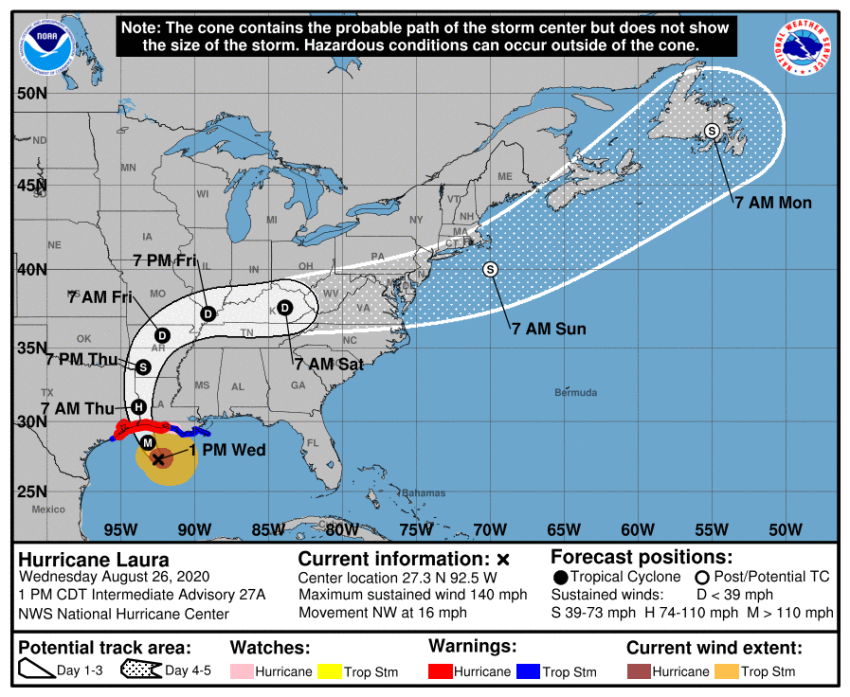
Hurricane Laura tracker: Projected path map of Category 4 storm; over 500K ordered to evacuate

Residents of coastal Texas and Louisiana have been urged to evacuate as Hurricane Laura has strengthened to Category 4 and is expected to make landfall late Wednesday with the potential to cause much devastation and deadly flooding.
As of early Wednesday afternoon, Hurricane Laura consisted of maximum sustained winds of 140 miles per hour, according to the National Hurricane Center, a division of the U.S. National Oceanic and Atmospheric Administration.
“Little time remains to protect life and property before water levels begin to rise and winds increase in the warning areas,” the NHC warned in a tweet.
1 PM CDT: #Laura is now an extremely dangerous category 4 hurricane with maximum winds of 140 MPH. Little time remains to protect life and property before water levels begin to rise and winds increase in the warning areas https://t.co/tW4KeFW0gBpic.twitter.com/6f9tvionaR
— National Hurricane Center (@NHC_Atlantic) August 26, 2020
With Laura swirling in the Gulf of Mexico and its landfall imminent, more than half a million people living along the Gulf Coast have been ordered to evacuate.
On Tuesday, over 385,000 residents were instructed to leave the cities of Beaumont, Galveston and Port Arthur in Texas.
In the low-lying Calcasieu Parish in southwest Louisiana, a mandatory evacuations order issued Tuesday affects more than 200,000 residents. Additionally, neighboring Cameron Parish is also under a mandatory order while parts of other parishes have been ordered to evacuate.
The projected path of Hurricane Laura shows the storm hovering around the Texas-Louisiana border Thursday morning with hurricane status.
As the day goes on, the storm is projected to move up into Arkansas as a tropical storm.
By Friday morning, Laura will be downgraded to a tropical depression as it continues to move east through Missouri, Illinois, Indiana, Kentucky and Tennessee over the weekend before moving out to sea early next week.
The Saffir-Simpson scale rates hurricanes based on their sustained wind speeds. A Category 4 hurricane has sustained winds ranging from 130 to 156 miles per hour.
According to the NHC, Category 4 hurricanes can result in “catastrophic damage,” including snapped trees, downed power lines and damage to the roofs and exterior walls of “well-built frame homes.”
In anticipation, the National Weather Service issued a series of watches and warnings for several areas along the Gulf Coast.
A hurricane warning extends from San Luis Pass, Texas, to Intracoastal City, Louisiana.
A tropical storm warning has been issued for the area east of Intracoastal City extending to the mouth of the Mississippi River. Another tropical storm warning is in effect from Sargent, Texas to San Luis Pass.
In addition to potentially damaging winds, residents of the Gulf Coast will also have to deal with a life-threatening storm surge.
A storm surge warning is in effect for the area from Freeport, Texas to the mouth of the Mississippi River.
The NHC predicts a peak storm surge of up to 20 feet in Louisiana’s Calcasieu Lake.
The latest rainfall forecast shows that the area surrounding the Texas and Louisiana border has the potential to see six to 10 inches of rain as a result of the hurricane.
Southwestern and central Arkansas, as well as the shared border of Louisiana, Texas and Arkansas, could see similar amounts of rainfall.
Residents in certain portions of eastern Texas, western Louisiana, central Arkansas, southeastern Missouri, northwestern Tennessee, southwestern Kentucky and even small portions of southern Illinois could see four to six inches of rainfall.
While the state of Mississippi will have to deal with storm surge, it will not see nearly as much rainfall as other states in the southeast.
Most of Mississippi is predicted to receive only one to two inches of rainfall. Some parts of Mississippi may see less than one inch of rain.
The rainfall from Hurricane Laura could extend into Kansas, Illinois, Indiana, West Virginia, Virginia and Ohio over the next five days, according to the NHC forecast.
Leaders at the state and federal level are taking action to make sure that the residents of the affected states remain safe.
Texas Gov. Greg Abbott issued a disaster declaration covering 59 counties. Louisiana Gov. John Bel Edwards activated the entire Louisiana National Guard for the first time since Hurricane Isaac, which ravaged the state in late August 2012.
President Donald Trump sent out a tweet Wednesday urging the residents of affected areas to “listen to local officials.”
“My Administration remains fully engaged with state & local emergency managers to continue preparing and assisting the great people (of) Texas, Louisiana, and Arkansas,” he wrote.
Hurricane Laura is a very dangerous and rapidly intensifying hurricane. My Administration remains fully engaged with state & local emergency managers to continue preparing and assisting the great people Texas, Louisiana, and Arkansas. Listen to local officials. We are with you! pic.twitter.com/x0JoijLUpb
— Donald J. Trump (@realDonaldTrump) August 26, 2020
As the people of the southeastern United States face another potentially catastrophic natural disaster, members of the faith community are sending their thoughts and prayers.
Rev. Franklin Graham, the son of the late evangelist Billy Graham and head of the evangelical humanitarian organization Samaritan’s Purse, asked his Twitter followers to “join me in prayer for those in the path of this destructive storm.”
#HurricaneLaura is forecast to make landfall in the upper Texas and southwest Louisiana coasts late today or early Thursday. I ask that you join me in prayer for those in the path of this destructive storm. https://t.co/gMswqDOKqX
— Franklin Graham (@Franklin_Graham) August 26, 2020
Hurricane Laura’s landfall coincides with the 15th anniversary of Hurricane Katrina’s landfall and the third anniversary of Hurricane Harvey. Both storms caused catastrophic damage along the gulf coast and across the southern U.S.


